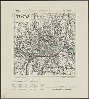
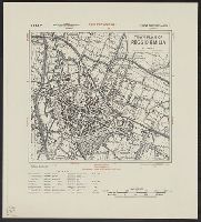
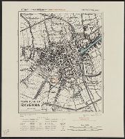
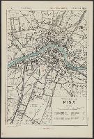
- Creator:
- Great Britain. War Office. General Staff. Geographical Section
- Published / Created:
- 1945
- Call Number:
- 5855 1945
- Container / Volume:
- BRBL_00315
- Image Count:
- 1
- Resource Type:
- Maps, Atlases & Globes
- Alternative Title:
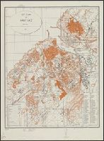
- G.S.G.S. ; no. 4474, GSGS (Series) ; no. 4474., and Kota Bharu
- Description:
- "Copied from a map prepared by Survey Department F.M.S., dated 1937. Revised, and roads reclassified by I.S.T.D., 1945. Photolithographed by the War Office, 1945." and Stamped "AMS 1 324197".
- Publisher:
- War Office,
- Subject (Geographic):
- Malaya--Maps
- Found in:
- Beinecke Rare Book and Manuscript Library > Malaya 1:380,160 : Kota Bharu Sheet No.2.
You Searched For
« Previous
| 1 - 50 of 150 |
Next »
Search Results
- Creator:
- Great Britain. War Office. General Staff. Geographical Section
- Published / Created:
- 1945
- Call Number:
- 5681 1945
- Container / Volume:
- BRBL_00300
- Image Count:
- 2
- Resource Type:
- Maps, Atlases & Globes
- Alternative Title:
- GSGS (Series), Hong Kong and Lema Islands, Hong Kong and Lema Islands., and Hong Kong and New territory.
- Description:
- "7-45.", "8-45.", "Reproduced under the direction of the Chief of Engineers by the Army Map Service (AM), U.S. Army ... 1945, from Kodalines of GSGS Second Edition 1945...", and North sheet. Hong Kong and New territory -- South sheet. Hong Kong and Lema Islands.
- Publisher:
- Army Map Service, U.S. Army,
- Subject (Geographic):
- Hong Kong (China)--Maps and New Territories (China)--Maps
- Subject (Name):
- United States. Army Map Service
- Found in:
- Beinecke Rare Book and Manuscript Library > Hong Kong and New territory.
- Creator:
- Great Britain. War Office. General Staff. Geographical Section
- Published / Created:
- 1945
- Call Number:
- 56 T83 1945
- Container / Volume:
- BRBL_00297
- Image Count:
- 1
- Resource Type:
- Maps, Atlases & Globes
- Alternative Title:
- Eastern China 1:50,000 : Tungchow and G.S.G.S. ; 3789
- Description:
- "Sheet 19/2,200"--Upper right margin., "Tungchow N3950-E11631/11x21"--Lower right margin., Includes legend., and Relief is shown by contours.
- Publisher:
- Army Map Service,
- Subject (Geographic):
- Tong Zhou (Beijing, China)--Maps
- Subject (Name):
- United States. Army Map Service
- Found in:
- Beinecke Rare Book and Manuscript Library > Tungchow [cartographic material] / Geographical Section, General Staff.
- Creator:
- Great Britain. War Office. General Staff. Geographical Section
- Published / Created:
- 1945
- Call Number:
- 56 Sh19 1945
- Container / Volume:
- BRBL_00297
- Image Count:
- 1
- Resource Type:
- Maps, Atlases & Globes
- Alternative Title:
- Eastern China 1:50,000: Shanhaikuan and G.S.G.S. ; 3789
- Description:
- "9-45.", "Geographical Section, General Staff, No. 3789. Published at the War Office 1927. First GSGS Edition (AMS 1), 1927; AMS Revisions (AMS 2), 1944.", "Shanhaikuan N3951-E11929/16x29"--Lower right margin., Includes legend., and Relief is shown by contours.
- Publisher:
- Army Map Service,
- Subject (Geographic):
- Shanhaiguan Qu (Qinhuangdao Shi, China)--Maps
- Found in:
- Beinecke Rare Book and Manuscript Library > Shanhaikuan [cartographic material] / Geographical Section, General Staff.
- Creator:
- Great Britain. War Office. General Staff. Geographical Section
- Published / Created:
- 1945
- Call Number:
- 56 Sh18 1945
- Container / Volume:
- BRBL_00297
- Image Count:
- 1
- Resource Type:
- Maps, Atlases & Globes
- Alternative Title:
- Geographic Section General Staff ; 3789 and GSGS (Series) ; 3789.
- Description:
- "9-45.", "Published by the War Office 1927.", At foot of map: Shanghai N3108-E12118/19., At head of map: Eastern China 1:50,000; Sheet 620/1,235., and N3108.
- Publisher:
- Army Map Service,
- Subject (Geographic):
- Shanghai (China)--Maps
- Subject (Name):
- United States. Army Map Service
- Found in:
- Beinecke Rare Book and Manuscript Library > Shanghai [cartographic material] / Geographical Section, General Staff.
6.
- Creator:
- Great Britain. War Office. General Staff. Geographical Section
- Published / Created:
- 1945
- Call Number:
- 56 P36 1945
- Container / Volume:
- BRBL_00297
- Image Count:
- 1
- Resource Type:
- Maps, Atlases & Globes
- Alternative Title:
- G.S.G.S. ; 3789
- Description:
- "9-45.", "Geographical Section, General Staff, No. 3789. Published at the War Office 1927. First GSGS Edition (AMS 1), 1926; Third GSGS Edition (AMS 2), 1944; AMS Revisions (AMS 3), 1944.", "Peking N3949-E11610/11x21"--Lower right margin., Includes legend., and R
- Publisher:
- Army Map Service,
- Subject (Geographic):
- Beijing (China)--Maps
- Found in:
- Beinecke Rare Book and Manuscript Library > Eastern China 1:50,000. Sheet 16/2,200, Peking / Geographical Section, General Staff [cartographic material].
- Creator:
- Great Britain. War Office. General Staff. Geographical Section
- Published / Created:
- 1945
- Call Number:
- 56 N15 1945
- Container / Volume:
- BRBL_00297
- Image Count:
- 1
- Resource Type:
- Maps, Atlases & Globes
- Alternative Title:
- [U.S. Army Map Service. A.M.S. ; L901], GSGS (Series) ; 3831., Its [G.S.G.S.] ; 3831, and Series (Standard map series designation system) ; L901.
- Description:
- "5-45.", "Contour interval 10 metres.", At head of title: China., Four classes of roads and paths are shown; some streets and buildings are named; areas of vegetation and cultivation are shown., and Military grid.
- Publisher:
- Army Map Service,
- Subject (Geographic):
- Nanjing (Jiangsu Sheng, China)--Maps
- Subject (Name):
- United States. Army Map Service
- Found in:
- Beinecke Rare Book and Manuscript Library > Nanking [cartographic material].
- Creator:
- Great Britain. War Office. General Staff. Geographical Section
- Published / Created:
- 1945
- Call Number:
- 56 C442 1945
- Container / Volume:
- BRBL_00296
- Image Count:
- 1
- Resource Type:
- Maps, Atlases & Globes
- Alternative Title:
- Great Britain. War Office. General Staff. Geographical Section. G.S.G.S. ; 2400. and Its G.S.G.S. ; 2400
- Description:
- "Form lines are shown at about 30 feet V.I.", "Polyconic projection.", "Published at W.O., Dec. 1908. G.S.G.S. revised edition, 1927-AMS 1, 1944.", In upper margin: China 1:63,360 ..., Military grid., and Soundings are shown for port areas.
- Publisher:
- Army Map Service, U.S. Army,
- Subject (Geographic):
- Beidaihe (China)--Maps and Qinhuangdao Shi (China)--Maps
- Found in:
- Beinecke Rare Book and Manuscript Library > Ch'in-wang-tao & Pei-tai-ho [cartographic material].
- Creator:
- Great Britain. War Office. General Staff. Geographical Section
- Published / Created:
- 1944
- Call Number:
- 428 IN7 1944
- Container / Volume:
- BRBL_00248
- Image Count:
- 2
- Resource Type:
- Maps, Atlases & Globes
- Alternative Title:
- G.S.G.S. ; 4483 and GSGS (Series) ; 4483.
- Description:
- "Copied from an Austrian plan. Drafting and reproduction by 654th Engineers, U.S. Army.", Alpha-numeric grid overlay., and Index to public buildings and streets on verso.
- Publisher:
- War Office,
- Subject (Geographic):
- Innsbruck (Austria)--Maps
- Found in:
- Beinecke Rare Book and Manuscript Library > Innsbruck and Environs [cartographic material].
- Creator:
- Great Britain. War Office. General Staff. Geographical Section
United States. Army Map Service - Published / Created:
- [19]44.
- Call Number:
- 352gme M94 1944
- Container / Volume:
- BRBL_00111
- Image Count:
- 1
- Resource Type:
- Maps, Atlases & Globes
- Alternative Title:
- Geographical Section, General Staff ; no. 4224 and GSGS (Series) ; no. 4224.
- Description:
- Below imprint: 9-44., Five classes of roads and paths are also indicated., In lower left corner of margin: War Office 1941., and In lower right corner of margin: Reproduced from a Finnish map.
- Publisher:
- The Service,
- Subject (Geographic):
- Soviet Union--Maps
- Subject (Topic):
- Railroads--Soviet Union--Maps
- Found in:
- Beinecke Rare Book and Manuscript Library > Murmansk railway. Sheet 2.
- Creator:
- Great Britain. War Office. General Staff. Geographical Section
- Published / Created:
- [19]44.
- Call Number:
- 352gme 1944
- Container / Volume:
- BRBL_00110
- Image Count:
- 1
- Resource Type:
- Maps, Atlases & Globes
- Alternative Title:
- Geographical Section, General Staff ; 4206 and GSGS ; 4206.
- Description:
- In lower left corner of margin: War Office, 1941., In lower right corner of margin: 9-44., In upper right margin: AMS 1., Insets: Donbass.-Leningrad.-Moscow., and Shows four types of railroads.
- Publisher:
- Army Map Service, U.S. Army,
- Subject (Geographic):
- Soviet Union--Maps
- Subject (Topic):
- Railroads--Soviet Union--Maps
- Found in:
- Beinecke Rare Book and Manuscript Library > Railways in western Russia.
- Creator:
- Great Britain. War Office. General Staff. Geographical Section
- Published / Created:
- 1944-
- Call Number:
- 341 1944
- Container / Volume:
- BRBL_00091
- Image Count:
- 2
- Resource Type:
- Maps, Atlases & Globes
- Alternative Title:
- Great Britain. War Office. General Staff. Geographical Section. G.S.G.S. ; 4479., Its G.S.G.S. 4479, and Series (Standard map series designation system) ; M514.
- Description:
- "Graticule based on the meridian of Copenhagen.", [U.S. Army Map Service. A.M.S. M514]., Complete in 3 sheets. Set includes various, Inset on sheet 3: Bornholm., Military grid., Relief shown by altitude tints, with heights in meters., and Sheet 1 lacking.
- Publisher:
- War Office,
- Subject (Geographic):
- Denmark--Maps
- Found in:
- Beinecke Rare Book and Manuscript Library > Denmark 1:250 000.
13.
- Creator:
- Great Britain. War Office. General Staff. Geographical Section
- Published / Created:
- 1944
- Call Number:
- 331 Ei61 1944
- Container / Volume:
- BRBL_00080
- Image Count:
- 1
- Resource Type:
- Maps, Atlases & Globes
- Alternative Title:
- G.S.G.S. ; 4458 and GSGS (Series) ; 4458.
- Description:
- Alpha-numeric grid., Copied from a Dutch plan., Important streets and buildings are named., and In upper margin: Holland.
- Publisher:
- War Office,
- Subject (Geographic):
- Eindhoven (Netherlands)--Maps
- Found in:
- Beinecke Rare Book and Manuscript Library > Eindhoven.
- Creator:
- Great Britain. War Office. General Staff. Geographical Section
- Published / Created:
- 1943-44.
- Call Number:
- 212 Sa58 1944
- Container / Volume:
- BRBL_00014
- Image Count:
- 1
- Resource Type:
- Maps, Atlases & Globes
- Alternative Title:
- [Series] M789, A.M.S. M789, G.S.G.S. ; no. 4124, and GSGS (Series) ; 4124.
- Description:
- "Contours at 25 metres interval.", East sheet, 1943., Five classes of roads or paths are shown., In upper margin: Azores 1:50,000 ..., Index map cataloged with G. S. G. S. 4122, G9132.S2 1942.G7a., Insets: Azores islands.--Ponta Delgada [on West, and Military grid.
- Publisher:
- Army Map Service, U. S. Army,
- Subject (Geographic):
- São Miguel Island (Azores)--Maps, Topographic
- Found in:
- Beinecke Rare Book and Manuscript Library > San Miguel island / drawn by the War Office.
- Creator:
- Great Britain. War Office. General Staff. Geographical Section
- Published / Created:
- 1943
- Call Number:
- 685gm 1943
- Container / Volume:
- BRBL_00351
- Image Count:
- 2
- Resource Type:
- Maps, Atlases & Globes
- Alternative Title:
- Geographical Section, General Staff ; no. 4408 and GSGS (Series) ; 4408.
- Description:
- "Copied from an Italian map date 1940, compiled by Sezione topografica del fronti Tunisini.", "Published by War Office, 1943.", Insets: Ghardimaou.--Nefza.--Souk-el-Arbd.--Souk, and Twelve classes of roads and tracks, and three gauges of railroads are indicated.
- Publisher:
- Army Map Service, U.S. Army,
- Subject (Geographic):
- Tunisia--Maps
- Subject (Topic):
- Transportation--Tunisia--Maps
- Found in:
- Beinecke Rare Book and Manuscript Library > Tunisie. Carte générale des routes, des pistes, et des points d'eau.
- Creator:
- Great Britain. War Office. General Staff. Geographical Section
- Published / Created:
- 1943
- Call Number:
- 685 T83 1943
- Container / Volume:
- BRBL_00351
- Image Count:
- 1
- Resource Type:
- Maps, Atlases & Globes
- Alternative Title:
- Geographical Section, General Staff ; no. 4274 and GSGS (Series) ; 4274.
- Description:
- Important streets and buildings are named., In upper margin: Tunisia 1:10,000 ..., Inset: Le Bardo. Scale 1:10,000., and Military grid.
- Publisher:
- Army Map Service, U. S. Army,
- Subject (Geographic):
- Tunis (Tunisia)--Maps
- Found in:
- Beinecke Rare Book and Manuscript Library > Town plan of Tunis / drawn by War Office.
- Creator:
- Great Britain. War Office. General Staff. Geographical Section
- Published / Created:
- 1943
- Call Number:
- 685 Sf18 1943
- Container / Volume:
- BRBL_00351
- Image Count:
- 1
- Resource Type:
- Maps, Atlases & Globes
- Alternative Title:
- GSGS (Series) ; 4275. and Provisional G.S.G.S. ; 4275
- Description:
- In upper margin: Tunisia 1:7,500 ... and Principal streets and buildings are named.
- Publisher:
- Army Map Service, U.S. Army,
- Subject (Geographic):
- Ṣafāqis (Tunisia)--Maps
- Found in:
- Beinecke Rare Book and Manuscript Library > Sfax; city plan. Drawn and reproduced by 512 Fd. survey coy. R. E.
- Creator:
- Great Britain. War Office. General Staff. Geographical Section
- Published / Created:
- 1943
- Call Number:
- 685 L13 1943
- Container / Volume:
- BRBL_00351
- Image Count:
- 1
- Resource Type:
- Maps, Atlases & Globes
- Alternative Title:
- Geographical Section, Genral Staff ; no. 4274 and GSGS (Series) ; 4274.
- Description:
- In upper margin: Tunisia 1:10,000 ..., Inset: [La Goulette and Tunis], and Military grid.
- Publisher:
- Army Map Service, U.S. Army,
- Subject (Geographic):
- La Goulette (Tunisia)--Maps
- Found in:
- Beinecke Rare Book and Manuscript Library > Town plan of La Goulette. Drawn by War Office, 1942.
- Creator:
- Great Britain. War Office. General Staff. Geographical Section
- Published / Created:
- 1943
- Call Number:
- 68 Si13 1943
- Container / Volume:
- BRBL_00350
- Image Count:
- 1
- Resource Type:
- Maps, Atlases & Globes
- Alternative Title:
- Geographical Section, General Staff ; no. 4275 and GSGS (Series) ; 4275.
- Description:
- "Prepared under the direction of the chief of engineers, U. S. Army, 1943. Compiled from aerial photographs, 1:12,000, G. S. G. S. no. 4275, Sidi Bel Abbès, 1942.", "Projection approximate.", and In upper margin: Algeria 1:10,000 ...
- Publisher:
- Army Map Service, U. S. Army,
- Subject (Geographic):
- Sidi Bel Abbès (Algeria)--Maps
- Found in:
- Beinecke Rare Book and Manuscript Library > Sidi Bel Abbès; city plan.
- Creator:
- Great Britain. War Office. General Staff. Geographical Section
- Published / Created:
- 1943
- Call Number:
- 68 B43 1943
- Container / Volume:
- BRBL_00350
- Image Count:
- 1
- Resource Type:
- Maps, Atlases & Globes
- Alternative Title:
- Geographical Section, General Staff ; no. 4275 and GSGS (Series) ; 4275.
- Description:
- "C. B. 4096 L ... Provisional ... Plan 45, Oct. 1942.", "Contours at 10 metres interval.", In upper margin: Algeria ..., and Military grid.
- Publisher:
- Army Map Service, U.S. Army,
- Subject (Geographic):
- Beni Saf (Algeria)--Maps
- Found in:
- Beinecke Rare Book and Manuscript Library > Town plan of Beni-Saf.
- Creator:
- Great Britain. War Office. General Staff. Geographical Section
- Published / Created:
- 1943
- Call Number:
- 679 T15 1943
- Container / Volume:
- BRBL_00349
- Image Count:
- 1
- Resource Type:
- Maps, Atlases & Globes
- Alternative Title:
- Geographical Section, General Staff ; no. 4241 and GSGS (Series) ; 4241.
- Description:
- "Contours at 5 metres interval.", "Key to numbers" lists points of interest; principal streets are named., "Published by War Office, 1941. 2nd edition, 1942. Revised by A. M. S. December 1942.", In upper margin: Morocco ..., and Military grid.
- Publisher:
- Army Map Service, U.S. Army,
- Subject (Geographic):
- Tangier (Morocco)--Maps
- Subject (Name):
- United States. Army Map Service
- Found in:
- Beinecke Rare Book and Manuscript Library > Town plan of Tangier.
- Creator:
- Great Britain. War Office. General Staff. Geographical Section
- Published / Created:
- 1943. and Army Map Service, U. S. Army,
- Call Number:
- 675 C33 1943
- Container / Volume:
- BRBL_00349
- Image Count:
- 1
- Resource Type:
- Maps, Atlases & Globes
- Alternative Title:
- Geographical Section, General Staff ; no. 4241 and GSGS (Series) ; 4241.
- Description:
- "Contours at 10 metres interval.", "Published by War office, 1942. Revised by A. M. S. December, 1942.", Important streets and buildings are named., In upper margin: Morocco ..., and Military grid.
- Subject (Geographic):
- Ceuta (Morocco)--Maps
- Subject (Name):
- United States. Army Map Service
- Found in:
- Beinecke Rare Book and Manuscript Library > Town plan of Ceuta.
- Creator:
- Great Britain. War Office. General Staff. Geographical Section
- Published / Created:
- 1943
- Call Number:
- 67 R11 1942
- Container / Volume:
- BRBL_00348
- Image Count:
- 1
- Resource Type:
- Maps, Atlases & Globes
- Alternative Title:
- Geographical Section, General Staff ; no. 4241 and GSGS (Series) ; 4035.
- Description:
- "Contours at 2.5 metre interval.", "Copied from a French map dated 1933." Published in 1941 and 1942 by War Office., "Legend" gives key to points of interest; important streets of Rabat are named., and Military grid.
- Publisher:
- Army Map Service, U.S. Army,
- Subject (Geographic):
- Rabat (Morocco)--Maps and Salé (Morocco)--Maps
- Found in:
- Beinecke Rare Book and Manuscript Library > City plan of Rabat-Salé ... 1942.
- Creator:
- Great Britain. War Office. General Staff. Geographical Section
- Published / Created:
- 1943
- Call Number:
- 60gm 1943
- Container / Volume:
- BRBL_00330
- Image Count:
- 1
- Resource Type:
- Maps, Atlases & Globes
- Alternative Title:
- Geographical Section, General Staff ; no. 4209 and GSGS (Series) ; 4209.
- Description:
- "Published by the War Office, 1941." and Shows three gauges of railroads, roads, tracks and telegraph cables.
- Publisher:
- Army Map Service, U.S. Army,
- Subject (Topic):
- Transportation--Africa--Maps
- Found in:
- Beinecke Rare Book and Manuscript Library > Africa : communications.
- Creator:
- Great Britain. War Office. General Staff. Geographical Section
- Published / Created:
- 1943
- Call Number:
- 56cbf 1942
- Container / Volume:
- BRBL_00297
- Image Count:
- 1
- Resource Type:
- Maps, Atlases & Globes
- Alternative Title:
- Great Britain. War Office. General Staff. Geographical Section. G.S.G.S. ; 4304. and Its [G.S.G.S.] ; 4304
- Description:
- "Drawn and reproduced by 512 (A. Fd. svy.) coy., R.E., Dec. 1941. Compiled from G.S.G.S. 4065 and 2957.", "Published by W.O. 1942.", Elevations shown by altitude tints., Marginal map: Index to adjoining sheet [Malaya] and boundaries., and Relief shown by contours
- Publisher:
- Army Map Service, U.S. Army,
- Subject (Geographic):
- East Asia--Maps
- Found in:
- Beinecke Rare Book and Manuscript Library > China and Japan [cartographic material] / compiled from G.S.G.S. 4065 and 2957.
- Creator:
- Great Britain. War Office. General Staff. Geographical Section
- Published / Created:
- 1943
- Call Number:
- 528 1943
- Container / Volume:
- BRBL_00283
- Image Count:
- 1
- Resource Type:
- Maps, Atlases & Globes
- Alternative Title:
- Geographical Section, General Staff ; no. 4035 and GSGS (Series) ; 4035.
- Description:
- "Form lines 50 ft. V. I.", Military grid., and Three classes of roads indicated.
- Publisher:
- Army Map Service, U.S. Army,
- Subject (Geographic):
- Bahrain--Maps
- Found in:
- Beinecke Rare Book and Manuscript Library > Bahrein island. Compiled from air photographs in A. H. Q. drawing office, Hinaidi, 1937. Drawn ... by O. S., 1939.
- Creator:
- Great Britain. War Office. General Staff. Geographical Section
- Published / Created:
- 1943
- Call Number:
- 501 1943
- Container / Volume:
- BRBL_00276
- Image Count:
- 1
- Resource Type:
- Maps, Atlases & Globes
- Alternative Title:
- Geographic Section, General Staff ; no. 4292 and GSGS (Series) ; 4292.
- Description:
- Elevation shown by contour lines and spot heights in meters., Importance of cities symbolized by print size., and Railroad lines are identicated.
- Publisher:
- Army Map Service, U.S. Army,
- Subject (Geographic):
- Turkey--Maps
- Subject (Name):
- United States. Army Map Service
- Found in:
- Beinecke Rare Book and Manuscript Library > Turkey [cartographic material].
- Creator:
- Great Britain. War Office. General Staff. Geographical Section
- Published / Created:
- 1943
- Call Number:
- 49 1943
- Container / Volume:
- BRBL_00268
- Image Count:
- 3
- Resource Type:
- Maps, Atlases & Globes
- Alternative Title:
- Great Britain. War Office. General Staff. Geographical Section. G.S.G.S. ; 4281. and Its [G.S.G.S.] 4281
- Description:
- [1.] Libye-Greece -- [2.] Grece-B. Egypte -- [3.] Turquie-Levant., Copied from a French map dated 1941., and In lower right corner: "3-43"
- Publisher:
- War Office,
- Subject (Geographic):
- Mediterranean Region--Maps and Middle East--Maps
- Found in:
- Beinecke Rare Book and Manuscript Library > Méditerranée orientale, 1:2,000,000.
29.
- Creator:
- Great Britain. War Office. General Staff. Geographical Section
- Published / Created:
- 1943
- Call Number:
- 4894 1943
- Container / Volume:
- BRBL_00267
- Image Count:
- 1
- Resource Type:
- Maps, Atlases & Globes
- Alternative Title:
- Geographical Section, General Staff ; no. 4160 and GSGS (Series) ; 4160.
- Description:
- "Contours at 200 metres vertical interval.", "Drawn at the Ordnance Survey Office, 1941.", Military grid., and Three classes of roads or tracks are shown.
- Publisher:
- Army Map Service, U.S. Army,
- Subject (Geographic):
- Crete (Greece)--Maps, Topographic
- Found in:
- Beinecke Rare Book and Manuscript Library > Crete.
- Creator:
- Great Britain. War Office. General Staff. Geographical Section
- Published / Created:
- 1943
- Call Number:
- 409 Sa79 1943
- Container / Volume:
- BRBL_00240
- Image Count:
- 1
- Resource Type:
- Maps, Atlases & Globes
- Alternative Title:
- G.S.G.S. ; no. 4378 and GSGS (Series) ; 4378.
- Description:
- "11,100/1/43. LR.", "Enlarged from the 1/25,000 Italian map dated 1931. Revisd from air photographs.", Important streets are named., Includes index of some buildings., Military grid., and Relief shown by spot heights.
- Publisher:
- Army Map Service, U.S. Army,
- Subject (Geographic):
- Sassari (Italy)--Maps
- Found in:
- Beinecke Rare Book and Manuscript Library > Town plan of Sassari [cartographic material].
- Creator:
- Great Britain. War Office. General Staff. Geographical Section
- Published / Created:
- 1943
- Call Number:
- 409 C17 1943
- Container / Volume:
- BRBL_00240
- Image Count:
- 1
- Resource Type:
- Maps, Atlases & Globes
- Alternative Title:
- Geographical Section, General Staff ; no. 4378, GSGS (Series) ; 4378., and Sardinia
- Description:
- "8-43.", "Form lines from air photographs at intervals of 20 metres.", "From C.I.U. plan of March 1943.", and Military grid.
- Publisher:
- Army Map Service, U.S. Army,
- Subject (Geographic):
- Carbonia (Italy)--Maps
- Subject (Name):
- United States. Army Map Service
- Found in:
- Beinecke Rare Book and Manuscript Library > Carbonia [cartographic material] / photolithographed by War Office, 1943.
32.
- Creator:
- Great Britain. War Office. General Staff. Geographical Section
- Published / Created:
- 1943
- Call Number:
- 408 V83 1943
- Container / Volume:
- BRBL_00239
- Image Count:
- 1
- Resource Type:
- Maps, Atlases & Globes
- Alternative Title:
- Geographical Section, General Staff ; no. 4379, GSGS (Series) ; 4379., and Sicily 1:5,000
- Description:
- "6-43.", "Air photographs have been used in the production of this plan.", "Authorities: Italy 1:25,000 G.S.G.S. no.4228 sheet 276 IV N.W.1941, Italy 1:100,000 G.S.G.S. no.4164 sheet 276 1942, intelligence informa, and Relief shown by contours and rock drawings.
- Publisher:
- Army Map Service, U.S. Army,
- Subject (Geographic):
- Vittoria (Italy)--Maps
- Subject (Name):
- United States. Army Map Service
- Found in:
- Beinecke Rare Book and Manuscript Library > Town plan of Vittoria [cartographic material] / drawn and photolithographed by War Office, 1943.
- Creator:
- Great Britain. War Office. General Staff. Geographical Section
- Published / Created:
- 1943
- Call Number:
- 408 Sy76 1943
- Container / Volume:
- BRBL_00239
- Image Count:
- 1
- Resource Type:
- Maps, Atlases & Globes
- Alternative Title:
- Geographical Section, General Staff ; no. 4379, GSGS (Series) ; 4379., Sicily 1:7,500, and Sicily 1:7,500, town plan of Siracusa
- Description:
- "Contours at 10 metres interval.", "Enlarged from the 1/25,000 Italian map dated 1927.", "Published by the War Office, 1942, 2nd edition, 1943.", "Revised from air photographs and intelligence reports up to, and Some buildings indicated; principal streets named.
- Publisher:
- Army Map Service, U.S. Army,
- Subject (Geographic):
- Syracuse (Italy)--Maps
- Subject (Name):
- United States. Army Map Service
- Found in:
- Beinecke Rare Book and Manuscript Library > Town plan of Siracusa [cartographic material] / photolithographed by the Ordnance Survey, 1943.
- Creator:
- Great Britain. War Office. General Staff. Geographical Section
- Published / Created:
- 1943
- Call Number:
- 408 P17 1943
- Container / Volume:
- BRBL_00239
- Image Count:
- 1
- Resource Type:
- Maps, Atlases & Globes
- Alternative Title:
- Geographical Section, General Staff ; no. 4379 and GSGS (Series) ; 4379.
- Description:
- "11,100/2/43.L.R.", "Enlarged from the 1/25,000 Italian map dated 1937.", "Revised from air photographs and Intelligence reports up to 1942.", Important buildings are number keyed and important streets are named., Military grid., and Relief shown by contours, hach
- Publisher:
- Army Map Service, U.S. Army,
- Subject (Geographic):
- Palermo (Italy)--Maps
- Subject (Name):
- United States. Army Map Service
- Found in:
- Beinecke Rare Book and Manuscript Library > Town plan of Palermo [cartographic material].
- Creator:
- Great Britain. War Office. General Staff. Geographical Section
- Published / Created:
- 1943
- Call Number:
- 408 N84 1943
- Container / Volume:
- BRBL_00239
- Image Count:
- 1
- Resource Type:
- Maps, Atlases & Globes
- Alternative Title:
- Geographical Section, General Staff ; no. 4379, GSGS (Series) ; 4379., and Sicily 1:5,000
- Description:
- "6-43.", "Air photographs have been used in the production of this plan.", Military grid., Relief shown by "form lines at 10 metres interval.", and Some important streets and buildings are named.
- Publisher:
- Army Map Service, U.S. Army,
- Subject (Geographic):
- Noto (Italy)--Maps
- Subject (Name):
- United States. Army Map Service
- Found in:
- Beinecke Rare Book and Manuscript Library > Town plan of Noto [cartographic material] / drawn and lithographed by War Office, 1943.
- Creator:
- Great Britain. War Office. General Staff. Geographical Section
- Published / Created:
- 1943
- Call Number:
- 408 M56 1943
- Container / Volume:
- BRBL_00239
- Image Count:
- 1
- Resource Type:
- Maps, Atlases & Globes
- Alternative Title:
- Geographical Section, General Staff ; no. 4379, GSGS (Series) ; 4379., Sicily 1:10,000, and Sicily 1:10,000, town plan of Messina
- Description:
- "6-43.", "Contours at 20 metres interval.", "Enlarged from the 1/25,000 Italian map dated 1906. Revised from air photographs and intelligence reports up to 1942.", "Published by the War Office, 1942, 2nd edition, 1943.", and Some streets and buildings are named.
- Publisher:
- Army Map Service,
- Subject (Geographic):
- Messina (Italy)--Maps
- Subject (Name):
- United States. Army Map Service
- Found in:
- Beinecke Rare Book and Manuscript Library > Town plan of Messina [cartographic material] / photolithographed by the Ordnance Survey, 1943.
- Creator:
- Great Britain. War Office. General Staff. Geographical Section
- Published / Created:
- 1943
- Call Number:
- 408 L61 1943
- Container / Volume:
- BRBL_00239
- Image Count:
- 1
- Resource Type:
- Maps, Atlases & Globes
- Alternative Title:
- Geographical Section, General Staff ; no. 4379, GSGS (Series) ; 4379., and Sicily 1:5,000
- Description:
- "5-43.", "Air photographs have been used in the production of this plan.", "Authorities, Licata 1:25,000 G.S.G.S. no.4228, 1941. Porto di, "Published by the War Office 1943.", Military grid., and Relief shown by contours, hachures, rock drawings, and spot heights.
- Publisher:
- Army Map Service, U.S. Army,
- Subject (Geographic):
- Licata (Italy)--Maps
- Subject (Name):
- United States. Army Map Service
- Found in:
- Beinecke Rare Book and Manuscript Library > Town plan of Licata [cartographic material] / drawn and photolithographed by War Office, 1943.
- Creator:
- Great Britain. War Office. General Staff. Geographical Section
- Published / Created:
- 1943
- Call Number:
- 408 En61 1943
- Container / Volume:
- BRBL_00239
- Image Count:
- 1
- Resource Type:
- Maps, Atlases & Globes
- Alternative Title:
- Geographical Section, General Staff ; no. 4379, GSGS (Series) ; 4379., Sicily 1:7,500, and Sicily 1:75,000, town plan of Enna
- Description:
- "6-43.", "Air photographs have been used in the production of this plan.", "Authorities: Italy 1:25,000 G.S.G.S. no. 4228, "Published by War Office 1943.", Relief shown by contours, hachures, and rock drawings., and Some streets and important buildings are named.
- Publisher:
- Army Map Service, U.S. Army,
- Subject (Geographic):
- Enna (Italy)--Maps
- Subject (Name):
- United States. Army Map Service
- Found in:
- Beinecke Rare Book and Manuscript Library > Town plan of Enna [cartographic material] / drawn and photolithographed by War Office, 1943.
- Creator:
- Great Britain. War Office. General Staff. Geographical Section
- Published / Created:
- 1943
- Call Number:
- 408 C27 1943
- Container / Volume:
- BRBL_00239
- Image Count:
- 1
- Resource Type:
- Maps, Atlases & Globes
- Alternative Title:
- Geographical Section, General Staff ; no. 4379, GSGS (Series) ; 4379., Sicily 1:5,000, and Sicily 1:5,000, town plan of Castelvetrano
- Description:
- "6-43.", "Air photographs have been used in the production of this plan.", "Authorities: Italy 1:100,000, G.S.G.S., no.4164, 1942; Italy 1:50,000, G.S.G.S., no.4229, 1941; intelligence information, 1943, "Published by War Office, 1943.", and Military grid (blue).
- Publisher:
- Army Map Service, U.S. Army,
- Subject (Geographic):
- Castelvetrano (Italy)--Maps
- Subject (Name):
- United States. Army Map Service
- Found in:
- Beinecke Rare Book and Manuscript Library > Town plan of Castelvetrano [cartographic material] / drawn and photolithographed by War Office, 1943.
- Creator:
- Great Britain. War Office. General Staff. Geographical Section
- Published / Created:
- 1943
- Call Number:
- 408 Ag84 1943
- Container / Volume:
- BRBL_00239
- Image Count:
- 1
- Resource Type:
- Maps, Atlases & Globes
- Alternative Title:
- Geographical Section, General Staff ; no. 4379, GSGS (Series) ; 4379., and Italy 1:5,000
- Description:
- "5-43.", "Enlarged, "Published by the War Office, 1942, 2nd edition, 1943.", A few important streets are named., Also shows power lines, railways, and aquaducts., Includes index to buildings., Military grid., and Relief shown by contours, hachures, and spot heights.
- Publisher:
- Army Map Service, U.S. Army,
- Subject (Geographic):
- Agrigento (Italy)--Maps
- Subject (Name):
- United States. Army Map Service
- Found in:
- Beinecke Rare Book and Manuscript Library > Town plan of Agrigento [cartographic material].
- Creator:
- Great Britain. War Office. General Staff. Geographical Section
- Published / Created:
- 1943
- Call Number:
- 40 V66 1943
- Image Count:
- 1
- Resource Type:
- Maps, Atlases & Globes
- Alternative Title:
- Geographical Section, General Staff ; no. 4380, GSGS (Series) ; 4380., Italy, and Italy, town plan of Vicenza
- Description:
- "12/42/G.S.G.S.", "3-43.", "Authorities: Carta d'Italie 1:25,000 1935, various guide book plans.", "Published by War Office 1942.", Important streets and buildings are named., Military grid (brown)., and Relief shown by hachures and spot heights.
- Publisher:
- Army Map Service, U.S. Army,
- Subject (Geographic):
- Vicenza (Italy)--Maps
- Subject (Name):
- United States. Army Map Service
- Found in:
- Beinecke Rare Book and Manuscript Library > Town plan of Vicenza [cartographic material].
- Creator:
- Great Britain. War Office. General Staff. Geographical Section
- Published / Created:
- 1943
- Call Number:
- 40 Ud5 1943
- Image Count:
- 1
- Resource Type:
- Maps, Atlases & Globes
- Alternative Title:
- Geographical Section, General Staff ; no. 4380, GSGS (Series) ; 4380., Italy, and Italy, town plan of Udine
- Description:
- "12/42/G.S.G.S.", "3-43.", "Authorities: Carte d'Italie 1:25,000, 1937, various guide book plans.", "Published by War Office 1942.", Important streets and buildings are named., Military grid (brown)., and Relief shown by hachures and spot heights.
- Publisher:
- Army Map Service, U.S. Army,
- Subject (Geographic):
- Udine (Italy)--Maps
- Subject (Name):
- United States. Army Map Service
- Found in:
- Beinecke Rare Book and Manuscript Library > Town plan of Udine [cartographic material].
- Creator:
- Great Britain. War Office. General Staff. Geographical Section
- Published / Created:
- 1943
- Call Number:
- 40 T729 1943
- Image Count:
- 1
- Resource Type:
- Maps, Atlases & Globes
- Alternative Title:
- Geographical Section, General Staff ; no. 4380, GSGS (Series) ; 4380., Italy, and Italy, town plan of Treviso
- Description:
- "12/42/G.S.G.S.", "3-43.", "Authorities, Carta d'Italia 1:25,000, 1934/6. Various guide book plans.", "Published by War Office 1942.", Important streets and buildings are named., Military grid., and Relief shown by hachures and spot heights.
- Publisher:
- Army Map Service, U.S. Army,
- Subject (Geographic):
- Treviso (Italy)--Maps
- Subject (Name):
- United States. Army Map Service
- Found in:
- Beinecke Rare Book and Manuscript Library > Town plan of Treviso [cartographic material].
- Creator:
- Great Britain. War Office. General Staff. Geographical Section
- Published / Created:
- 1943
- Call Number:
- 40 R261 1943
- Container / Volume:
- BRBL_00215
- Image Count:
- 1
- Resource Type:
- Maps, Atlases & Globes
- Alternative Title:
- Geographical Section, General Staff; no.4380 and GSGS (Series) ; 4380.
- Description:
- Important streets and buildings are named., In upper margin: Italy ..., and Military grid.
- Publisher:
- Army Map Service, U.S. Army,
- Subject (Geographic):
- Reggio Emilia (Italy)--Maps
- Found in:
- Beinecke Rare Book and Manuscript Library > Town plan of Reggio Emilia [cartographic material].
- Creator:
- Great Britain. War Office. General Staff. Geographical Section
- Published / Created:
- 1943
- Call Number:
- 40 R19 1943
- Container / Volume:
- BRBL_00215
- Image Count:
- 1
- Resource Type:
- Maps, Atlases & Globes
- Alternative Title:
- Geographical Section, General Staff ; no. 4380, GSGS (Series) ; 4380., and Italy
- Description:
- "12/42/G.S.G.S.", "3-43.", "Authorities, Carta d'Italia 1:25,000, 1935.", "Published by War Office 1942.", Important streets and buildings are named., Military grid., and Relief shown by hachures.
- Publisher:
- Army Map Service, U.S. Army,
- Subject (Geographic):
- Ravenna (Italy)--Maps
- Subject (Name):
- United States. Army Map Service
- Found in:
- Beinecke Rare Book and Manuscript Library > Town plan of Ravenna [cartographic material].
- Creator:
- Great Britain. War Office. General Staff. Geographical Section
- Published / Created:
- 1943
- Call Number:
- 40 P67 1943
- Container / Volume:
- BRBL_00214
- Image Count:
- 1
- Resource Type:
- Maps, Atlases & Globes
- Alternative Title:
- Geographical Section, General Staff ; no. 4380 and GSGS (Series) ; 4380.
- Description:
- "12/42/G.S.G.S.", "Authorities ... Carta d'Italia 1:25,000 1928 ...", "Published by War Office 1942.", "Reprint January 1943.", Important streets and buildings are named., In upper margin: Italy., Military grid., and Relief shown by hachures.
- Publisher:
- Army Map Service, U.S. Army,
- Subject (Geographic):
- Pisa (Italy)--Maps
- Subject (Name):
- United States. Army Map Service
- Found in:
- Beinecke Rare Book and Manuscript Library > Town plan of Pisa [cartographic material].
- Creator:
- Great Britain. War Office. General Staff. Geographical Section
- Published / Created:
- 1943
- Call Number:
- 40 P57 1943
- Container / Volume:
- BRBL_00214
- Image Count:
- 1
- Resource Type:
- Maps, Atlases & Globes
- Alternative Title:
- Geographical Section, General Staff ; no. 4380, GSGS (Series) ; 4380., and Italy
- Description:
- "3-43.", "Published by War Office, 1942.", Important streets and buildings are named., and Military grid.
- Publisher:
- Army Map Service, U.S. Army,
- Subject (Geographic):
- Piacenza (Italy)--Maps
- Subject (Name):
- United States. Army Map Service
- Found in:
- Beinecke Rare Book and Manuscript Library > Town plan of Piacenza [cartographic material].
- Creator:
- Great Britain. War Office. General Staff. Geographical Section
- Published / Created:
- 1943
- Call Number:
- 40 P24 1943
- Container / Volume:
- BRBL_00213
- Image Count:
- 1
- Resource Type:
- Maps, Atlases & Globes
- Alternative Title:
- Geographical Section, General Staff ; no. 4380 and GSGS (Series) ; 4380.
- Description:
- "12/42/G.S.G.S.", "3-43.", "Authorities, Carta d'Italia 1:25,000 1935 ...", Important streets and buildings are named., In upper margin: Italy., Military grid., and Relief shown by hachures and spot heights.
- Publisher:
- Army Map Service, U.S. Army,
- Subject (Geographic):
- Parma (Italy)--Maps
- Subject (Name):
- United States. Army Map Service
- Found in:
- Beinecke Rare Book and Manuscript Library > Town plan of Parma [cartographic material].
- Creator:
- Great Britain. War Office. General Staff. Geographical Section
- Published / Created:
- 1943
- Call Number:
- 40 P19 1942
- Container / Volume:
- BRBL_00213
- Image Count:
- 1
- Resource Type:
- Maps, Atlases & Globes
- Alternative Title:
- Geographical Section, General Staff ; no. 4162 and GSGS (Series) ; 4162.
- Description:
- "3-43.", "Copied from an Italian map of 1896.", "Grid added November 1942.", Military grid., and Relief shown by contours, rock drawings, and spot heights.
- Publisher:
- Army Map Service, U.S. Army,
- Subject (Geographic):
- Pantelleria Island (Italy)--Maps
- Subject (Name):
- United States. Army Map Service
- Found in:
- Beinecke Rare Book and Manuscript Library > Pantelleria [cartographic material] / drawn by GSGS, War Office 1940.
- Creator:
- Great Britain. War Office. General Staff. Geographical Section
- Published / Created:
- 1943
- Call Number:
- 40 P13 1943
- Container / Volume:
- BRBL_00213
- Image Count:
- 1
- Resource Type:
- Maps, Atlases & Globes
- Alternative Title:
- Geographical Section, General Staff ; no. 4380, GSGS (Series) ; 4380., and Italy
- Description:
- "2-43.", "Published by War Office, 1942.", Important streets and buildings are named., and Military grid.
- Publisher:
- Army Map Service, U.S. Army,
- Subject (Geographic):
- Padua (Italy)--Maps
- Subject (Name):
- United States. Army Map Service
- Found in:
- Beinecke Rare Book and Manuscript Library > Town plan of Padua (Padova) [cartographic material].