
Search


Limit your search
- Public55
- cartographic✖[remove]55
- English54
- Great Britain. War Office. General Staff. Geographical Section30
- United States. Army. Corps of Engineers6
- Great Britain. Inter-service Topographical Dept3
- U.S. Coast and Geodetic Survey3
- Great Britain. Army. Royal Engineers. Fd. Survey Coy., 5122
- United States. Army Map Service2
- British Columbia. Dept. of Lands1
- Egypt. Maṣlaḥat al-Misāḥah1
- Great Britain. Army. Middle East Forces1
- Great Britain. Army. Royal Engineers. Field Survey Coy., 19th1
- Military maps6
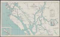
- Coasts--British Columbia--Maps1
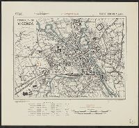
- Marinas--Italy--Vibo Valentia--Maps1
- Military geography--Japan--Kagoshima--Maps1
- Military geography--Japan--Nagasaki--Maps1
- Military topography--Japan--Kagoshima--Maps1
- Military topography--Japan--Nagasaki--Maps1
- Transportation--Malta--Maps1
- Transportation--Minnesota--Maps1
- Transportation--Wisconsin--Maps1
Current results range from 1940 to 1947