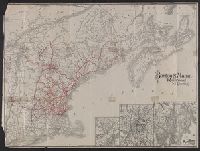
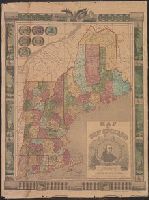
Search
You Searched For
Search Results
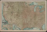
- Published / Created:
- 1857
- Call Number:
- 75gme 1857
- Container / Volume:
- BRBL_00412
- Image Count:
- 2
- Resource Type:
- Maps, Atlases & Globes
- Found in:
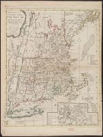
- Beinecke Rare Book and Manuscript Library > A new and complete Rail Road map of the United States / compiled from reliable sources by William Perris ; presented by the Home Insurance Company of New York ; Korff Brothers, Practical Lithographers, New York.
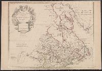
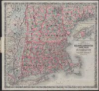
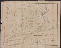
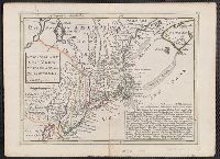
- Published / Created:
- 1776]
- Call Number:
- 766 1776
- Container / Volume:
- BRBL_00690
- Image Count:
- 1
- Resource Type:
- Maps, Atlases & Globes
- Found in:
- Beinecke Rare Book and Manuscript Library > A map of Connecticut and Rhode Island with Long Island Sound, &c.
- Published / Created:
- 1776]
- Call Number:
- 766 1776
- Container / Volume:
- BRBL_00690
- Image Count:
- 1
- Resource Type:
- Maps, Atlases & Globes
- Found in:
- Beinecke Rare Book and Manuscript Library > A map of Connecticut and Rhode Island with Long Island Sound, &c.
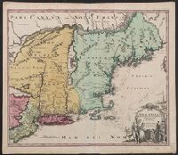
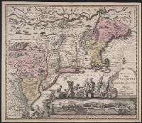
- Creator:
- Tirion, Isaak
- Published / Created:
- [1769]
- Call Number:
- 755 1755F
- Container / Volume:
- BRBL_00427
- Image Count:
- 1
- Resource Type:
- Maps, Atlases & Globes
- Found in:
- Beinecke Rare Book and Manuscript Library > Nieuwe kaart van de grootbrittannische Volkplantingen in Noort America .../ Isaak Tirion 1755.
- Creator:
- Tirion, Isaak
- Published / Created:
- [1769]
- Call Number:
- 755 1755Z
- Container / Volume:
- BRBL_00427
- Image Count:
- 1
- Resource Type:
- Maps, Atlases & Globes
- Found in:
- Beinecke Rare Book and Manuscript Library > Nieuwe kaart van de grootbrittannische Volkplantingen in Noort America .../ Isaak Tirion 1755.
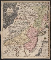
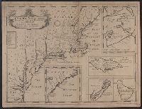
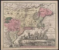
- Creator:
- Robert Sayer and John Bennett (Firm)
- Call Number:
- 755 1776K
- Container / Volume:
- BRBL_00430
- Image Count:
- 1
- Resource Type:
- Maps, Atlases & Globes
- Alternative Title:
- , Nova-Scotia, New-England, New-York, New
- Subject (Geographic):
- New England--Maps--Early works to 1800
- Found in:
- Beinecke Rare Book and Manuscript Library > A general map of the northern British colonies in America : which comprehends the province of Quebec, the government of Newfoundland, Nova-Scotia, New-England and New-York, from the maps published by the Admiralty and Board of Trade, regulated by the astr
- Published / Created:
- [1755?]
- Call Number:
- 71 1755G
- Container / Volume:
- BRBL_00363
- Image Count:
- 1
- Resource Type:
- Maps, Atlases & Globes
- Subject (Geographic):
- New England--Maps--Early works to 1800
- Found in:
- Beinecke Rare Book and Manuscript Library > Carta d'una parte dell' America Settentrionale : che serve per ben poter intendere le pretensioni delli Inglesi, esposte ne loro memoriali in occasione della regolazione de limiti con la Francia nell' America svdetta.
- Creator:
- Fer, Nicolas de, 1646-1720
- Published / Created:
- 1719?]
- Call Number:
- 71 1719B
- Container / Volume:
- BRBL_00687
- Image Count:
- 1
- Resource Type:
- Maps, Atlases & Globes
- Found in:
- Beinecke Rare Book and Manuscript Library > Carte de la Nouvelle France : où se voit le cours des grandes rivieres de S. Laurens & de Mississipi, aujour d'hui S. Louïs, aux environs des-quelles se trouvent les etats, païs, nations, peuples &c. de la Floride, de la Louïsiane, de la Virginie, de
- Creator:
- Fer, Nicolas de, 1646-1720
- Published / Created:
- 1719?]
- Call Number:
- 71 1719B
- Container / Volume:
- BRBL_00361
- Image Count:
- 1
- Resource Type:
- Maps, Atlases & Globes
- Found in:
- Beinecke Rare Book and Manuscript Library > Carte de la Nouvelle France : où se voit le cours des grandes rivieres de S. Laurens & de Mississipi, aujour d'hui S. Louïs, aux environs des-quelles se trouvent les etats, païs, nations, peuples &c. de la Floride, de la Louïsiane, de la Virginie, de
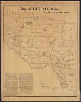
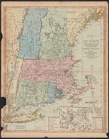
- Published / Created:
- 1871
- Call Number:
- 761 B98 1870
- Container / Volume:
- BRBL_00448
- Image Count:
- 1
- Resource Type:
- Maps, Atlases & Globes
- Publisher:
- New England Lith. Co. ,
- Found in:
- Beinecke Rare Book and Manuscript Library > Map of Buxton, Maine / by Daniel Dennet, 1870.
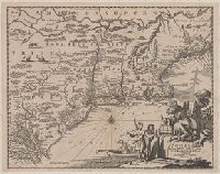
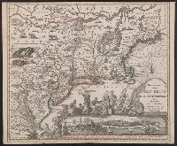
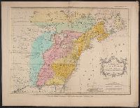
- Published / Created:
- [1774]
- Call Number:
- 76 1774
- Container / Volume:
- BRBL_00729
- Image Count:
- 1
- Resource Type:
- Maps, Atlases & Globes
- Abstract:
- Subject: Map of New England and Long
- Subject (Geographic):
- New England--Maps
- Found in:
- Beinecke Rare Book and Manuscript Library > A Map of the most inhabited part of New England [cartographic material] : containing the provinces of Massachusets Bay and New Hampshire with the colonies of Conecticut and Rhode Island divided into counties and townships : The whole composed from actual
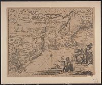
- Published / Created:
- [1774]
- Call Number:
- 76 1774
- Container / Volume:
- BRBL_00729
- Image Count:
- 2
- Resource Type:
- Maps, Atlases & Globes
- Abstract:
- Subject: Map of New England and Long
- Subject (Geographic):
- New England--Maps
- Found in:
- Beinecke Rare Book and Manuscript Library > A Map of the most inhabited part of New England [cartographic material] : containing the provinces of Massachusets Bay and New Hampshire with the colonies of Conecticut and Rhode Island divided into counties and townships : The whole composed from actual
- Published / Created:
- [1774]
- Call Number:
- 76 1774
- Container / Volume:
- BRBL_00443
- Image Count:
- 2
- Resource Type:
- Maps, Atlases & Globes
- Abstract:
- Subject: Map of New England and Long
- Subject (Geographic):
- New England--Maps
- Found in:
- Beinecke Rare Book and Manuscript Library > A Map of the most inhabited part of New England [cartographic material] : containing the provinces of Massachusets Bay and New Hampshire with the colonies of Conecticut and Rhode Island divided into counties and townships : The whole composed from actual
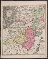
- Creator:
- Lotter, Tobias Conrad, 1717-1777
- Published / Created:
- 1760?]
- Call Number:
- 755 1760E
- Container / Volume:
- BRBL_00428
- Image Count:
- 1
- Resource Type:
- Maps, Atlases & Globes
- Description:
- Also covers New England (distorted) and
- Subject (Geographic):
- New England--Maps--Early works to 1800
- Found in:
- Beinecke Rare Book and Manuscript Library > Pensylvania, Nova Jersey et Nova York cum regionibus ad Fluvium Delaware in America sitis / nova delineatione ob oculos posita per Tob. Conr. Lotter, geographum Aug. Vind. ; Tob. Conr. Lotter sculps. Aug. V.
- Creator:
- Homann, Johann Baptist, 1663-1724
- Published / Created:
- 1716?]
- Call Number:
- 76 1759
- Container / Volume:
- BRBL_00729
- Image Count:
- 1
- Resource Type:
- Maps, Atlases & Globes
- Description:
- New England.
- Subject (Geographic):
- New England--Maps--Early works to 1800
- Found in:
- Beinecke Rare Book and Manuscript Library > Nova Anglia septentrionali Americae implantata Anglorumque coloniis florentissima geographice exhibita / [cartographic material] / a Ioh. Baptista Homann ...
- Creator:
- Lotter, Tobias Conrad, 1717-1777
- Published / Created:
- 1760?]
- Call Number:
- 755 1760E
- Container / Volume:
- BRBL_00728
- Image Count:
- 1
- Resource Type:
- Maps, Atlases & Globes
- Description:
- Also covers New England (distorted) and
- Subject (Geographic):
- New England--Maps--Early works to 1800
- Found in:
- Beinecke Rare Book and Manuscript Library > Pensylvania, Nova Jersey et Nova York cum regionibus ad Fluvium Delaware in America sitis / nova delineatione ob oculos posita per Tob. Conr. Lotter, geographum Aug. Vind. ; Tob. Conr. Lotter sculps. Aug. V.
- Creator:
- Lotter, Tobias Conrad, 1717-1777
- Published / Created:
- 1760?]
- Call Number:
- 75 1730
- Container / Volume:
- BRBL_00689
- Image Count:
- 1
- Resource Type:
- Maps, Atlases & Globes
- Description:
- Also covers New England (distorted) and
- Subject (Geographic):
- New England--Maps--Early works to 1800
- Found in:
- Beinecke Rare Book and Manuscript Library > Pensylvania, Nova Jersey et Nova York cum regionibus ad Fluvium Delaware in America sitis / nova delineatione ob oculos posita per Tob. Conr. Lotter, geographum Aug. Vind. ; Tob. Conr. Lotter sculps. Aug. V.
- Creator:
- Kitchin, Thomas, d. 1784
- Published / Created:
- 1778
- Call Number:
- 76 1778
- Container / Volume:
- BRBL_00690
- Image Count:
- 2
- Resource Type:
- Maps, Atlases & Globes
- Subject (Geographic):
- New England--Maps--Early works to 1800
- Found in:
- Beinecke Rare Book and Manuscript Library > A map of the colony of Rhode Island [cartographic material] : with the adjacent parts of Connecticut, Massachusetts Bay, & c / by Thos. Kitchin Senr., Hydrographer to His Majesty.
- Creator:
- Bowen, Emanuel, d. 1767
- Published / Created:
- 1754
- Call Number:
- 75 1720
- Container / Volume:
- BRBL_00689
- Image Count:
- 1
- Resource Type:
- Maps, Atlases & Globes
- Found in:
- Beinecke Rare Book and Manuscript Library > A map of the British American plantations [cartographic material] : extending from Boston in New England to Georgia, including all the back settlements in the respective provinces, as far as the Mississippi / by Eman. Bowen Geogr. to His Majesty ; Tho. Bo
- Creator:
- Lotter, Matthäus Albrecht, 1741-1810
- Published / Created:
- 1776?]
- Call Number:
- 755 1778D
- Container / Volume:
- BRBL_00432
- Image Count:
- 1
- Resource Type:
- Maps, Atlases & Globes
- Found in:
- Beinecke Rare Book and Manuscript Library > Carte nouvelle de l'Amérique angloise contenant tout ce que les Anglois possedent sur le continent de l'Amérique septentrionale savoir le Canada : la Nouvelle Ecosse ou Acadie, les treize provinces unies qui font : les quatres colonies de la Nouvelle An
- Creator:
- Lotter, Matthäus Albrecht, 1741-1810
- Published / Created:
- 1776?]
- Call Number:
- 755 1778
- Container / Volume:
- BRBL_00690
- Image Count:
- 1
- Resource Type:
- Maps, Atlases & Globes
- Found in:
- Beinecke Rare Book and Manuscript Library > Carte nouvelle de l'Amérique angloise contenant tout ce que les Anglois possedent sur le continent de l'Amérique septentrionale savoir le Canada : la Nouvelle Ecosse ou Acadie, les treize provinces unies qui font : les quatres colonies de la Nouvelle An
- Creator:
- Lotter, Matthäus Albrecht, 1741-1810
- Published / Created:
- 1776?]
- Call Number:
- 755 1776E
- Container / Volume:
- BRBL_00430
- Image Count:
- 1
- Resource Type:
- Maps, Atlases & Globes
- Found in:
- Beinecke Rare Book and Manuscript Library > Carte nouvelle de l'Amérique angloise contenant tout ce que les Anglois possedent sur le continent de l'Amérique septentrionale savoir le Canada : la Nouvelle Ecosse ou Acadie, les treize provinces unies qui font : les quatres colonies de la Nouvelle An
- Creator:
- Lotter, Matthäus Albrecht, 1741-1810
- Published / Created:
- 1776?]
- Call Number:
- 71 1776L
- Container / Volume:
- BRBL_00726
- Image Count:
- 1
- Resource Type:
- Maps, Atlases & Globes
- Found in:
- Beinecke Rare Book and Manuscript Library > Carte nouvelle de l'Amérique angloise contenant tout ce que les Anglois possedent sur le continent de l'Amérique septentrionale savoir le Canada : la Nouvelle Ecosse ou Acadie, les treize provinces unies qui font : les quatres colonies de la Nouvelle An
- Published / Created:
- ca. 1747?]
- Call Number:
- 771 1760
- Container / Volume:
- BRBL_00690
- Image Count:
- 1
- Resource Type:
- Maps, Atlases & Globes
- Found in:
- Beinecke Rare Book and Manuscript Library > Map of Hudson's River, with the adjacent country [cartographic material].
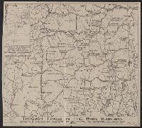
- Published / Created:
- 1917
- Call Number:
- 762gmb 1917
- Container / Volume:
- BRBL_00451
- Image Count:
- 1
- Resource Type:
- Maps, Atlases & Globes
- Description:
- Inset: Key map of New England showing
- Found in:
- Beinecke Rare Book and Manuscript Library > Through trails in the White Mountains : maintained by the organizations comprising the New England Trail Conference.
- Creator:
- Wells, Edward, 1667-1727
- Published / Created:
- 1722?]
- Call Number:
- 755 1722
- Container / Volume:
- BRBL_00425
- Image Count:
- 1
- Resource Type:
- Maps, Atlases & Globes
- Found in:
- Beinecke Rare Book and Manuscript Library > A new map of the most considerable plantations of the English in America : dedicated to His Highness William Duke of Glocester / Sutton Nichols sculp.
- Creator:
- Ely, William Watson
- Published / Created:
- 1878
- Call Number:
- 771 Ad47 1878
- Container / Volume:
- BRBL_00480
- Image Count:
- 1
- Resource Type:
- Maps, Atlases & Globes
- Description:
- Inset map of New York State and New
- Subject (Geographic):
- New England--Maps
- Found in:
- Beinecke Rare Book and Manuscript Library > Map of the New York Wilderness and the Adirondacks.
- Creator:
- Overton, Henry, 1675 or 6-1751
- Published / Created:
- [1755?]
- Call Number:
- 755 1756F
- Container / Volume:
- BRBL_00428
- Image Count:
- 1
- Resource Type:
- Maps, Atlases & Globes
- Found in:
- Beinecke Rare Book and Manuscript Library > An accurate map of the British colonies in North America bordering on the river Ohio.
- Creator:
- Homann, Johann Baptist, 1663-1724
- Published / Created:
- 1759?]
- Call Number:
- 755 1759A
- Container / Volume:
- BRBL_00428
- Image Count:
- 1
- Resource Type:
- Maps, Atlases & Globes
- Description:
- Cf. McCorkle, B.B. New England in early
- Subject (Geographic):
- New England--Maps--Early works to 1800
- Found in:
- Beinecke Rare Book and Manuscript Library > Nova Anglia septentrionali Americae implantata Anglorumque coloniis florentissima geographice exhibita / [cartographic material] / a Ioh. Baptista Homann ...
- Creator:
- Thornton, John, fl. 1652-1701
- Published / Created:
- [1673?]
- Call Number:
- 755 1682B
- Container / Volume:
- BRBL_00424
- Image Count:
- 1
- Resource Type:
- Maps, Atlases & Globes
- Alternative Title:
- , New-York & New England
- Description:
- Inset: "A mapp of New England".
- Subject (Geographic):
- New England--Maps--Early works to 1800
- Found in:
- Beinecke Rare Book and Manuscript Library > A mapp of Virginia, Mary-land, New-Jarsey, New-York, & New England.
- Creator:
- Morden, Robert, d. 1703
- Published / Created:
- [1676?]
- Call Number:
- 755 1675E
- Container / Volume:
- BRBL_00423
- Image Count:
- 1
- Resource Type:
- Maps, Atlases & Globes
- Alternative Title:
- Map of New England, New Yorke, New
- Subject (Geographic):
- New England--Maps--Early works to 1800
- Found in:
- Beinecke Rare Book and Manuscript Library > A map of New England, New Yorke, New Jersey, Mary-land & Virginia / Gr. King sculpsit.
- Creator:
- Speed, John, 1552?-1629
- Published / Created:
- [1676]
- Call Number:
- 755 1672A
- Container / Volume:
- BRBL_00423
- Image Count:
- 2
- Resource Type:
- Maps, Atlases & Globes
- Subject (Geographic):
- New England--Maps--Early works to 1800
- Found in:
- Beinecke Rare Book and Manuscript Library > A map of New England and New York / F. Lamb sculp.
- Creator:
- Kitchin, Thomas, d. 1784
- Published / Created:
- 1766?]
- Call Number:
- 755 1763A
- Container / Volume:
- BRBL_00428
- Image Count:
- 1
- Resource Type:
- Maps, Atlases & Globes
- Found in:
- Beinecke Rare Book and Manuscript Library > A new and accurate map of the British dominions in America, according to the Treaty of 1763, divided into the several provinces and jurisdictions : projected upon the best authorities and astronomical observations / by Thos. Kitchin, geographer.
- Creator:
- Kitchin, Thomas, d. 1784
- Published / Created:
- 1780?]
- Call Number:
- 755 1760
- Container / Volume:
- BRBL_00428
- Image Count:
- 1
- Resource Type:
- Maps, Atlases & Globes
- Found in:
- Beinecke Rare Book and Manuscript Library > British dominions in America : drawn from the latest and best authorities / by Thos. Kitchin, hydrographer to his majesty.
- Creator:
- Montanus, Arnoldus, 1625?-1683
- Published / Created:
- 1671?]
- Call Number:
- 755 1671B
- Container / Volume:
- BRBL_00680
- Image Count:
- 1
- Resource Type:
- Maps, Atlases & Globes
- Subject (Geographic):
- New England--Maps--Early works to 1800
- Found in:
- Beinecke Rare Book and Manuscript Library > Novi Belgii, quod nunc Novi Jorck vocatur, Novae q[ue] Angliae & partis Virginiae : accuratissima et novissima delineatio.
- Creator:
- Montanus, Arnoldus, 1625?-1683
- Published / Created:
- 1671?]
- Call Number:
- 755 1671B
- Container / Volume:
- BRBL_00423
- Image Count:
- 1
- Resource Type:
- Maps, Atlases & Globes
- Subject (Geographic):
- New England--Maps--Early works to 1800
- Found in:
- Beinecke Rare Book and Manuscript Library > Novi Belgii, quod nunc Novi Jorck vocatur, Novae q[ue] Angliae & partis Virginiae : accuratissima et novissima delineatio.
- Creator:
- Wytfliet, Corneille
- Published / Created:
- 1597
- Call Number:
- 755 1597
- Container / Volume:
- BRBL_00728
- Image Count:
- 1
- Resource Type:
- Maps, Atlases & Globes
- Found in:
- Beinecke Rare Book and Manuscript Library > Norumbega et Virginia, 1597 [cartographic material].
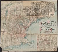
- Creator:
- Poole Brothers
- Published / Created:
- [1903]
- Call Number:
- 76gme 1903
- Container / Volume:
- BRBL_00446A
- Image Count:
- 1
- Resource Type:
- Maps, Atlases & Globes
- Subject (Topic):
- Ferries--New England--Maps
- Found in:
- Beinecke Rare Book and Manuscript Library > The New York, New Haven and Hartford Railroad and connections.
- Creator:
- H.H. Lloyd & Co
- Published / Created:
- c1855.
- Call Number:
- 753 1855
- Container / Volume:
- BRBL_00415
- Image Count:
- 1
- Resource Type:
- Maps, Atlases & Globes
- Alternative Title:
- Tourist's map of New York, New England
- Description:
- , New England, and Canada.
- Subject (Geographic):
- New England--Maps
- Found in:
- Beinecke Rare Book and Manuscript Library > Lloyd's map of the Canadas, New York, & New England.
- Creator:
- Homann, Johann Baptist, 1663-1724
- Published / Created:
- 1759?]
- Call Number:
- 75 1710
- Container / Volume:
- BRBL_00689
- Image Count:
- 1
- Resource Type:
- Maps, Atlases & Globes
- Description:
- Cf. McCorkle, B.B. New England in early
- Subject (Geographic):
- New England--Maps--Early works to 1800
- Found in:
- Beinecke Rare Book and Manuscript Library > Nova Anglia septentrionali Americae implantata Anglorumque coloniis florentissima geographice exhibita / [cartographic material] / a Ioh. Baptista Homann ...
- Creator:
- New England Railway Publishing Company
- Published / Created:
- c1901.
- Call Number:
- 75gme 1902A
- Container / Volume:
- BRBL_00414
- Image Count:
- 1
- Resource Type:
- Maps, Atlases & Globes
- Found in:
- Beinecke Rare Book and Manuscript Library > The ABC Pathfinder Railway Guide, Eastern Section / issued by the New England Railway Publishing Company.
- Creator:
- New England Railway Publishing Company
- Published / Created:
- c1902.
- Call Number:
- 75gme 1902B
- Container / Volume:
- BRBL_00414
- Image Count:
- 1
- Resource Type:
- Maps, Atlases & Globes
- Found in:
- Beinecke Rare Book and Manuscript Library > The ABC Pathfinder Railway Guide, Western Section / issued by the New England Railway Publishing Company.
- Creator:
- Seller, John, fl. 1658-1698
- Published / Created:
- [1675]
- Call Number:
- 76 1675
- Image Count:
- 1
- Resource Type:
- Maps, Atlases & Globes
- Description:
- : A description of New-England (4 p. ; 46
- Subject (Geographic):
- New England--Maps--Early works to 1800
- Found in:
- Beinecke Rare Book and Manuscript Library > A mapp of New England / by John Seller, hydrographer to the King.
- Published / Created:
- 1783
- Call Number:
- 755 1783
- Container / Volume:
- BRBL_00434
- Image Count:
- 1
- Resource Type:
- Maps, Atlases & Globes
- Description:
- Canada with "Etats Unis" added across New
- Found in:
- Beinecke Rare Book and Manuscript Library > Carte du Canada qui comprend la partie septentrionale des Etats-Unis d'Amerique ... par Guillaume Del'Isle ...
- Creator:
- Kitchin, Thomas, 1718-1784
- Published / Created:
- 1756
- Call Number:
- 755 1765A
- Container / Volume:
- BRBL_00690
- Image Count:
- 1
- Resource Type:
- Maps, Atlases & Globes
- Found in:
- Beinecke Rare Book and Manuscript Library > A map of the eastern part of the Province of New York : with part of New Jersey &c. / drawn from the best authorities by T. Kitchin geogr.
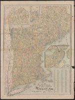
- Creator:
- National Publishing Company (Boston, Mass.)
- Published / Created:
- 1898
- Call Number:
- 76 1898
- Container / Volume:
- BRBL_00445
- Image Count:
- 1
- Resource Type:
- Maps, Atlases & Globes
- Alternative Title:
- Map of New England showing state
- Subject (Geographic):
- New England--Maps
- Subject (Topic):
- Post Office Buildings--New England
- Found in:
- Beinecke Rare Book and Manuscript Library > New post office, township, county and railroad map of New England : with distances.
- Published / Created:
- 1755]
- Call Number:
- 755 1755A
- Container / Volume:
- BRBL_00690
- Image Count:
- 1
- Resource Type:
- Maps, Atlases & Globes
- Description:
- Shows New England, Maritime Provinces
- Subject (Geographic):
- New England--Maps--Early works to 1800
- Found in:
- Beinecke Rare Book and Manuscript Library > A map of the British & French Plantations in North America.
- Creator:
- Bellin, Jacques Nicolas, 1703-1772
- Published / Created:
- 1757
- Call Number:
- BrSides 2018 139
- Image Count:
- 1
- Resource Type:
- Maps, Atlases & Globes
- Subject (Geographic):
- New England--Maps--Early works to 1800.
- Found in:
- Beinecke Rare Book and Manuscript Library > Carte de la Nouvelle Angleterre, Nouvelle Yorck, et Pensilvanie / pour servir à l'Histoire générale des voyages. Par M.B., ing. de la mare.
- Creator:
- Homann Erben (Firm)
- Published / Created:
- 1756
- Call Number:
- 71 1756H
- Container / Volume:
- BRBL_00726
- Image Count:
- 1
- Resource Type:
- Maps, Atlases & Globes
- Found in:
- Beinecke Rare Book and Manuscript Library > America Septentrionalis a Domino d'Anville in Galliis edita nunc in Anglia : coloniis in interiorem Virginiam deductis nec non Fluvii Ohio cursu aucta notisque geographicis et historicis illustrata / sumptibus Homannianorum Heredum.
- Creator:
- Homann Erben (Firm)
- Published / Created:
- 1756
- Call Number:
- 755 1756B
- Container / Volume:
- BRBL_00428
- Image Count:
- 1
- Resource Type:
- Maps, Atlases & Globes
- Found in:
- Beinecke Rare Book and Manuscript Library > America Septentrionalis a Domino d'Anville in Galliis edita nunc in Anglia : coloniis in interiorem Virginiam deductis nec non Fluvii Ohio cursu aucta notisque geographicis et historicis illustrata / sumptibus Homannianorum Heredum.
- Creator:
- Homann Erben (Firm)
- Published / Created:
- 1756
- Call Number:
- 755 1756Ea
- Container / Volume:
- BRBL_00428
- Image Count:
- 1
- Resource Type:
- Maps, Atlases & Globes
- Found in:
- Beinecke Rare Book and Manuscript Library > America Septentrionalis a Domino d'Anville in Galliis edita nunc in Anglia : coloniis in interiorem Virginiam deductis nec non Fluvii Ohio cursu aucta notisque geographicis et historicis illustrata / sumptibus Homannianorum Heredum.
- Creator:
- Homann Erben (Firm)
- Published / Created:
- 1756
- Call Number:
- 755 1756G
- Container / Volume:
- BRBL_00690
- Image Count:
- 1
- Resource Type:
- Maps, Atlases & Globes
- Found in:
- Beinecke Rare Book and Manuscript Library > America Septentrionalis a Domino d'Anville in Galliis edita nunc in Anglia : coloniis in interiorem Virginiam deductis nec non Fluvii Ohio cursu aucta notisque geographicis et historicis illustrata / sumptibus Homannianorum Heredum.
- Creator:
- Homann Erben (Firm)
- Published / Created:
- 1777
- Call Number:
- 71 1777H
- Container / Volume:
- BRBL_00726
- Image Count:
- 1
- Resource Type:
- Maps, Atlases & Globes
- Found in:
- Beinecke Rare Book and Manuscript Library > America Septentrionalis a Domino d'Anville in Galliis edita nunc in Anglia : coloniis in interiorem Virginiam deductis nec non Fluvii Ohio cursu aucta notisque geographicis et historicis illustrata et ad bellum praesentis temporis accomodata / sumptibus H
- Creator:
- Güssefeld, F. L. (Franz Ludwig), 1744-1807
- Published / Created:
- ao. 1784.
- Call Number:
- 755 1784A
- Container / Volume:
- BRBL_00435
- Image Count:
- 1
- Resource Type:
- Maps, Atlases & Globes
- Found in:
- Beinecke Rare Book and Manuscript Library > Charte über die XIII vereinigte Staaten von Nord-Amerika / entworfen durch F.L. Güssefeld und herausgegeben von den Homaennischen Erben.
- Creator:
- Güssefeld, F. L. (Franz Ludwig), 1744-1807
- Published / Created:
- ao. 1784.
- Call Number:
- 75 1784G
- Container / Volume:
- BRBL_00727
- Image Count:
- 1
- Resource Type:
- Maps, Atlases & Globes
- Found in:
- Beinecke Rare Book and Manuscript Library > Charte über die XIII vereinigte Staaten von Nord-Amerika / entworfen durch F.L. Güssefeld und herausgegeben von den Homaennischen Erben.
- Creator:
- Williams, Alexander
- Published / Created:
- 1852
- Call Number:
- 76GM 1852
- Container / Volume:
- BRBL_00446
- Image Count:
- 1
- Resource Type:
- Maps, Atlases & Globes
- Alternative Title:
- Telegraph and rail road map of the New
- Subject (Geographic):
- New England--Maps
- Subject (Topic):
- Railroads--New England--Maps
- Found in:
- Beinecke Rare Book and Manuscript Library > Williams' telegraph and rail road map of the New England states : Eastern portion of New York state and Canada/ compiled from the most authentic sources by Alexander Williams.
- Creator:
- Rand Avery Supply Co
- Published / Created:
- 1885
- Call Number:
- 753gme 1885
- Container / Volume:
- BRBL_00415
- Image Count:
- 2
- Resource Type:
- Maps, Atlases & Globes
- Description:
- Covers New England excluding Maine, and
- Subject (Topic):
- Railroads--New England--Maps
- Found in:
- Beinecke Rare Book and Manuscript Library > Map of the Boston & Lowell Railroad System : with its principal connections.
- Creator:
- Rand Avery Supply Co
- Published / Created:
- [1911?]
- Call Number:
- 76gme 1910
- Container / Volume:
- BRBL_00446A
- Image Count:
- 1
- Resource Type:
- Maps, Atlases & Globes
- Subject (Geographic):
- New England--Maps
- Subject (Topic):
- Railroads--New England--Maps
- Found in:
- Beinecke Rare Book and Manuscript Library > Boston & Maine Railroad and connections / Rand Avery Supply Co.
- Creator:
- G.W. & C.B. Colton & Co
- Published / Created:
- 1886
- Call Number:
- 76 1886
- Container / Volume:
- BRBL_00445
- Image Count:
- 1
- Resource Type:
- Maps, Atlases & Globes
- Subject (Geographic):
- New England--Maps
- Subject (Topic):
- Railroads--New England--Maps
- Found in:
- Beinecke Rare Book and Manuscript Library > Colton's railroad & township map of Massachusetts, Rhode Island and Connecticut : with parts of Maine, New Hampshire, Vermont & New York.
- Creator:
- Boston and Maine Railroad. General Passenger Dept
- Published / Created:
- [1900?]
- Call Number:
- 76gme 1900
- Container / Volume:
- BRBL_00446A
- Image Count:
- 2
- Resource Type:
- Maps, Atlases & Globes
- Subject (Geographic):
- New England--Maps
- Subject (Topic):
- Railroads--New England--Maps
- Found in:
- Beinecke Rare Book and Manuscript Library > Summer resorts of the coast, lake, and mountain regions along the Boston & Maine Railroad and connections.
- Creator:
- Seutter, Matthaeus, 1678-1756
- Published / Created:
- 1730?]
- Call Number:
- 755 1735B
- Container / Volume:
- BRBL_00426
- Image Count:
- 1
- Resource Type:
- Maps, Atlases & Globes
- Subject (Geographic):
- New England--Maps--Early works to 1800
- Found in:
- Beinecke Rare Book and Manuscript Library > Recens edita totius Novi Belgii in America Septentrionali siti / delineatio cura et sumptibus Matthaei Seutteri, Sac. Caes. Maj. Geographi August. Vind.
- Creator:
- Seutter, Matthaeus, 1678-1756
- Published / Created:
- 1730?]
- Call Number:
- 755 1676A
- Container / Volume:
- BRBL_00689
- Image Count:
- 1
- Resource Type:
- Maps, Atlases & Globes
- Subject (Geographic):
- New England--Maps--Early works to 1800
- Found in:
- Beinecke Rare Book and Manuscript Library > Recens edita totius Novi Belgii in America Septentrionali siti / delineatio cura et sumptibus Matthaei Seutteri, Sac. Caes. Maj. Geographi August. Vind.
- Creator:
- Seutter, Matthaeus, 1678-1756
- Published / Created:
- 1730?]
- Call Number:
- 771 1740
- Container / Volume:
- BRBL_00729
- Image Count:
- 1
- Resource Type:
- Maps, Atlases & Globes
- Subject (Geographic):
- New England--Maps--Early works to 1800
- Found in:
- Beinecke Rare Book and Manuscript Library > Recens edita totius Novi Belgii in America Septentrionali siti / delineatio cura et sumptibus Matthaei Seutteri, Sac. Caes. Maj. Geographi August. Vind.
- Creator:
- Lossing & Barritt
- Published / Created:
- 1847
- Call Number:
- 76 1847
- Container / Volume:
- BRBL_00445
- Image Count:
- 1
- Resource Type:
- Maps, Atlases & Globes
- Description:
- of New England states in upper
- Subject (Geographic):
- New England--Maps
- Found in:
- Beinecke Rare Book and Manuscript Library > Map of New England / Lossing-Barritt, sc.
- Creator:
- Swett and Powers (Firm)
- Published / Created:
- [ca. 1851?]
- Call Number:
- 76gme 1850
- Container / Volume:
- BRBL_00446A
- Image Count:
- 1
- Resource Type:
- Maps, Atlases & Globes
- Subject (Topic):
- Railroads--New England--Maps
- Found in:
- Beinecke Rare Book and Manuscript Library > Map of the New York & Boston Railway : with its connections with other railways.
- Creator:
- Robert Sayer and John Bennett (Firm)
- Published / Created:
- 1776
- Call Number:
- 755 1776
- Container / Volume:
- BRBL_00430
- Image Count:
- 1
- Resource Type:
- Maps, Atlases & Globes
- Found in:
- Beinecke Rare Book and Manuscript Library > A general map of the middle British colonies, in America [cartographic material] : Containing Virginia, Maryland, the Delaware counties, Pennsylvania and New Jersey. With the addition of New York, and the greatest part of New England, as also of the borde
- Published / Created:
- [1804?]
- Call Number:
- 76 1804
- Container / Volume:
- BRBL_00443
- Image Count:
- 1
- Resource Type:
- Maps, Atlases & Globes
- Subject (Geographic):
- New England--Maps
- Found in:
- Beinecke Rare Book and Manuscript Library > Bowles's New one-sheet map of New England; ...
- Published / Created:
- 1849
- Call Number:
- 76 1849
- Container / Volume:
- BRBL_00445
- Image Count:
- 1
- Resource Type:
- Maps, Atlases & Globes
- Subject (Geographic):
- New England--Maps
- Found in:
- Beinecke Rare Book and Manuscript Library > Map of New England. New York and Buffalo.
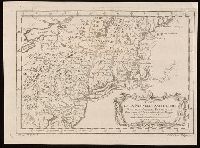
- Published / Created:
- [1736?]
- Call Number:
- 755 1736
- Container / Volume:
- BRBL_00728
- Image Count:
- 1
- Resource Type:
- Maps, Atlases & Globes
- Found in:
- Beinecke Rare Book and Manuscript Library > New England, New York, New Jersey and Pensylvania.
- Creator:
- Bowen, Thomas, -1790
- Published / Created:
- 1755]
- Call Number:
- BrSides Folio 2019 104
- Image Count:
- 1
- Resource Type:
- Maps, Atlases & Globes
- Description:
- scotia, Newfoundland, New England, part of
- Found in:
- Beinecke Rare Book and Manuscript Library > A map of the British and French settlements in North America / T. Bowen, sculpt.
- Published / Created:
- [1775?]
- Call Number:
- 76cea 1775A
- Container / Volume:
- BRBL_00446
- Image Count:
- 1
- Resource Type:
- Maps, Atlases & Globes
- Description:
- Insets: The Town of Boston in New
- Subject (Geographic):
- New England--Maps--Early works to 1800
- Found in:
- Beinecke Rare Book and Manuscript Library > A Map of the Coast of New England from Staten Island to the Island of Breton; as it was actualy survey'd by Capt Cyprian Southback.
- Creator:
- Palairet, Jean, 1697-1774
- Published / Created:
- 1755
- Call Number:
- 755 1755E
- Container / Volume:
- BRBL_00427
- Image Count:
- 1
- Resource Type:
- Maps, Atlases & Globes
- Found in:
- Beinecke Rare Book and Manuscript Library > Carte des possessions angloises & françoises du continent de l'Amérique septentrionale / Thos. Kitchin, sculpt.
- Published / Created:
- [1775?]
- Call Number:
- 76cea 1775
- Container / Volume:
- BRBL_00446
- Image Count:
- 1
- Resource Type:
- Maps, Atlases & Globes
- Description:
- Insets: The Town of Boston in new
- Subject (Geographic):
- New England--Maps--Early works to 1800
- Found in:
- Beinecke Rare Book and Manuscript Library > A Map of the Coast of New England from Staten Island of Breton; as if was actualy survey'd by Capt. Cyprian Southback.
- Published / Created:
- [1702?]
- Call Number:
- 76 1702A
- Container / Volume:
- BRBL_00443
- Image Count:
- 1
- Resource Type:
- Maps, Atlases & Globes
- Subject (Geographic):
- New England--Maps--Early works to 1800
- Found in:
- Beinecke Rare Book and Manuscript Library > An exact map of New England and New York.
- Creator:
- Moll, Herman, -1732
- Published / Created:
- 1715
- Call Number:
- 755 1715C
- Container / Volume:
- BRBL_00425
- Image Count:
- 1
- Resource Type:
- Maps, Atlases & Globes
- Found in:
- Beinecke Rare Book and Manuscript Library > A new and exact map of the dominions of the King of Great Britain on ye continent of North America [cartographic material] : containing Newfoundland, New Scotland, New England, New York, New Jersey, Pensilvania, Maryland, Virginia and Carolina according t
- Creator:
- Rhode, Johann Christoph, cartographer
- Call Number:
- 755 1755AA
- Container / Volume:
- BRBL_00427
- Image Count:
- 1
- Resource Type:
- Maps, Atlases & Globes
- Description:
- , Early printed maps of New England 1513-1800
- Found in:
- Beinecke Rare Book and Manuscript Library > Theatrum belli in America Septentrionali / II. foliis comprehensum jussu Acad. Reg. Scient. et Eleg. Litt. exhibet I. C. Rhode Ac: Geogr. ; Berger, sculpsit berol.
- Creator:
- Palairet, Jean, 1697-1774
- Published / Created:
- 1756
- Call Number:
- 755 1756D
- Container / Volume:
- BRBL_00428
- Image Count:
- 1
- Resource Type:
- Maps, Atlases & Globes
- Found in:
- Beinecke Rare Book and Manuscript Library > Carte des possessions angloises & françoises du continent de l'Amérique septentrionale / par I. Palairet, Londres ; Thos. Kitchin, sculpt.
- Creator:
- Palairet, Jean, 1697-1774
- Published / Created:
- 1755
- Call Number:
- 755 1763
- Container / Volume:
- BRBL_00428
- Image Count:
- 1
- Resource Type:
- Maps, Atlases & Globes
- Found in:
- Beinecke Rare Book and Manuscript Library > Carte des possessions angloises & françoises du continent de l'Amérique septentrionale / Thos. Kitchin, sculpt.
- Creator:
- Colton, G. Woolworth (George Woolworth), 1827-1901
- Published / Created:
- 1866, c1860.
- Call Number:
- 753 1866C
- Container / Volume:
- BRBL_00415
- Image Count:
- 1
- Resource Type:
- Maps, Atlases & Globes
- Alternative Title:
- New England
- Description:
- Area includes all of New England and
- Subject (Geographic):
- New England--Maps
- Subject (Topic):
- Railroads--New England--Maps
- Found in:
- Beinecke Rare Book and Manuscript Library > G. Woolworth Colton's railroad, township & distance map of New England : with adjacent portions of New York, Canada & New Brunswick.
- Published / Created:
- [1760?]
- Call Number:
- 76 1760
- Container / Volume:
- BRBL_00443
- Image Count:
- 1
- Resource Type:
- Maps, Atlases & Globes
- Subject (Geographic):
- New England--Maps--Early works to 1800
- Found in:
- Beinecke Rare Book and Manuscript Library > A map of the most inhabited part of New England ...
- Published / Created:
- 1771
- Call Number:
- 76 1771
- Container / Volume:
- BRBL_00443
- Image Count:
- 1
- Resource Type:
- Maps, Atlases & Globes
- Subject (Geographic):
- New England--Maps--Early works to 1800
- Found in:
- Beinecke Rare Book and Manuscript Library > A map of the most inhabited part of New England ...
- Published / Created:
- 1776
- Call Number:
- 76 1776A
- Container / Volume:
- BRBL_00443
- Image Count:
- 1
- Resource Type:
- Maps, Atlases & Globes
- Subject (Geographic):
- New England--Maps--Early works to 1800
- Found in:
- Beinecke Rare Book and Manuscript Library > Bowles's Map of the Seat of War in New England ...
- Creator:
- Blaeu, Willem Janszoon, 1571-1638
- Published / Created:
- 163-?]
- Call Number:
- 755 1635
- Container / Volume:
- BRBL_00422
- Image Count:
- 1
- Resource Type:
- Maps, Atlases & Globes
- Subject (Geographic):
- New England--Maps--Early works to 1800
- Found in:
- Beinecke Rare Book and Manuscript Library > Nova Belgica et Anglia Nova.
- Creator:
- Visscher, Nicolaes, 1618-1679
- Published / Created:
- 1655?]
- Call Number:
- 75 1655
- Container / Volume:
- BRBL_00689
- Image Count:
- 1
- Resource Type:
- Maps, Atlases & Globes
- Subject (Geographic):
- New England--Maps--Early works to 1800
- Found in:
- Beinecke Rare Book and Manuscript Library > Novi Belgii, Novaeque Angliae nec non partis Virginiae tabula / [cartographic material] / multis in locis emendata a Nicolao Joannis Visschero.
- Creator:
- Visscher, Nicolaes, 1618-1679
- Published / Created:
- 1655?]
- Call Number:
- 755 1655
- Container / Volume:
- BRBL_00423
- Image Count:
- 1
- Resource Type:
- Maps, Atlases & Globes
- Subject (Geographic):
- New England--Maps--Early works to 1800
- Found in:
- Beinecke Rare Book and Manuscript Library > Novi Belgii, Novaeque Angliae nec non partis Virginiae tabula / [cartographic material] / multis in locis emendata a Nicolao Joannis Visschero.
- Creator:
- Robert Sayer and John Bennett (Firm)
- Call Number:
- 755 1776G
- Container / Volume:
- BRBL_00430
- Image Count:
- 1
- Resource Type:
- Maps, Atlases & Globes
- Alternative Title:
- , Nova-Scotia, New-England, New-York, New
- Description:
- B.B. McCorkle, New England in early
- Subject (Geographic):
- New England--Maps--Early works to 1800
- Found in:
- Beinecke Rare Book and Manuscript Library > A general map of the Northern British Colonies in America, which comprehends the Province of Quebec, the government of Newfoundland, Nova-Scotia, New-England and New York : from the surveys of Capt. Cook & Capt. Carver, regulated by the astronomic & trigo
- Creator:
- Burgis, William, active 1722-1736
- Published / Created:
- 1869
- Call Number:
- 764 B65 1729
- Container / Volume:
- BRBL_00454
- Image Count:
- 1
- Resource Type:
- Maps, Atlases & Globes
- Alternative Title:
- Plan of Boston in New England
- Found in:
- Beinecke Rare Book and Manuscript Library > To His Excellency William Burnet, Esq., this Plan of Boston in New England is humbly dedicated / engraved by Thos. Johnson.
- Creator:
- Lodge, John, -1796
- Published / Created:
- 31st July 1785.
- Call Number:
- 732 1785
- Container / Volume:
- BRBL_00376A
- Image Count:
- 1
- Resource Type:
- Maps, Atlases & Globes
- Description:
- Shows Maritime Provinces, New England
- Subject (Geographic):
- New England--Maps--Early works to 1800
- Found in:
- Beinecke Rare Book and Manuscript Library > A new map of Nova Scotia, and Cape Britain [cartographic material] : With the adjacent parts of New England and Canada, from the latest authorities / J. Lodge sc.
- Published / Created:
- 1890?]
- Call Number:
- 76 1890
- Container / Volume:
- BRBL_00445
- Image Count:
- 1
- Resource Type:
- Maps, Atlases & Globes
- Description:
- Covers New England and the Maritime
- Subject (Geographic):
- New England--Maps
- Subject (Topic):
- Railroads--New England--Maps
- Found in:
- Beinecke Rare Book and Manuscript Library > Map of the Maine Central R.R. : the White Mountains & Mount Desert route / Rand Avery Supply Co., engr's.
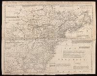
- Creator:
- Mitchell, John, 1711-1768
- Published / Created:
- [1755]
- Call Number:
- 71 1755D
- Image Count:
- 8
- Resource Type:
- Maps, Atlases & Globes
- Found in:
- Beinecke Rare Book and Manuscript Library > A map of the British and French dominions in North America : with the roads, distances, limits, and extent of the settlements, humbly inscribed to the Right Honourable the Earl of Halifax, and the other Right Honourable the Lords Commissioners for Trade &
- Creator:
- Mitchell, John, 1711-1768
- Published / Created:
- [1755]
- Call Number:
- 71 1755D
- Container / Volume:
- BRBL_00363
- Image Count:
- 8
- Resource Type:
- Maps, Atlases & Globes
- Found in:
- Beinecke Rare Book and Manuscript Library > A map of the British and French dominions in North America : with the roads, distances, limits, and extent of the settlements, humbly inscribed to the Right Honourable the Earl of Halifax, and the other Right Honourable the Lords Commissioners for Trade &
- Creator:
- Le Rouge, Georges-Louis
- Published / Created:
- 1755
- Call Number:
- BrSides Double Folio 2019 112
- Image Count:
- 1
- Resource Type:
- Maps, Atlases & Globes
- Found in:
- Beinecke Rare Book and Manuscript Library > Canada et Louisiane / par le Sr. Le Rouge, ingenieur geographe du roy.
- Creator:
- Le Rouge, Georges-Louis
- Published / Created:
- 1755
- Call Number:
- 755 1755L
- Container / Volume:
- BRBL_00427
- Image Count:
- 1
- Resource Type:
- Maps, Atlases & Globes
- Found in:
- Beinecke Rare Book and Manuscript Library > Canada et Louisiane / par le Sr. Le Rouge, ingenieur geographe du roy.
- Creator:
- Lattré, Jean
- Published / Created:
- 1784
- Call Number:
- 75 1784
- Container / Volume:
- BRBL_00396
- Image Count:
- 1
- Resource Type:
- Maps, Atlases & Globes
- Found in:
- Beinecke Rare Book and Manuscript Library > Carte des Etats-Unis de l'Amerique suivant le Traité de Paix de 1783 : dédiée et présentée a s. excellence Mr. Benjamin Franklin... / par son très humble et très obeissant Serviteur Lattré.
- Published / Created:
- 1776
- Call Number:
- 764 B65 1776B
- Container / Volume:
- BRBL_00455
- Image Count:
- 1
- Resource Type:
- Maps, Atlases & Globes
- Found in:
- Beinecke Rare Book and Manuscript Library > An accurate map of the country round Boston in New England ...